
Eulerian or Lagrangian: The Importance of Reference Frames for Remote Sensing
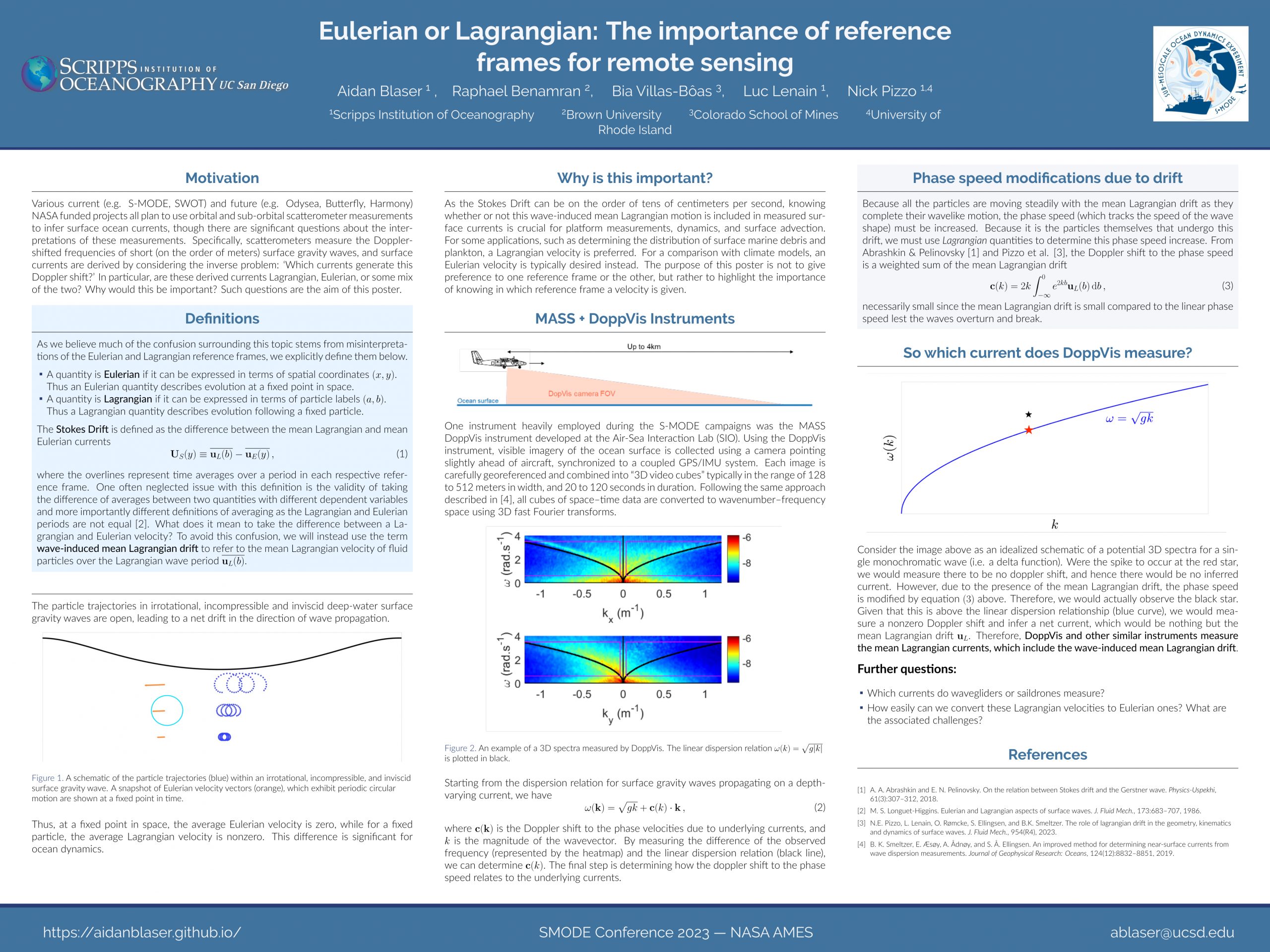 Various current (e.g. S-MODE, SWOT) and future (e.g. Odysea, Butterfly, Harmony) NASA funded projects all plan to use orbital and sub-orbital scatterometer measurements to infer surface ocean currents, though there are significant questions about the interpretations of these measurements. Specifically, scatterometers measure the Dopplershifted frequencies of short (on the order of meters) surface gravity waves, and surface currents are derived by considering the inverse problem: ‘Which currents generate this Doppler shift?’ In particular, are these derived currents Lagrangian, Eulerian, or some mix of the two? Why would this be important? Such questions are the aim of this poster.
Modulation of Surface Gravity Waves at a Submesoscale Front
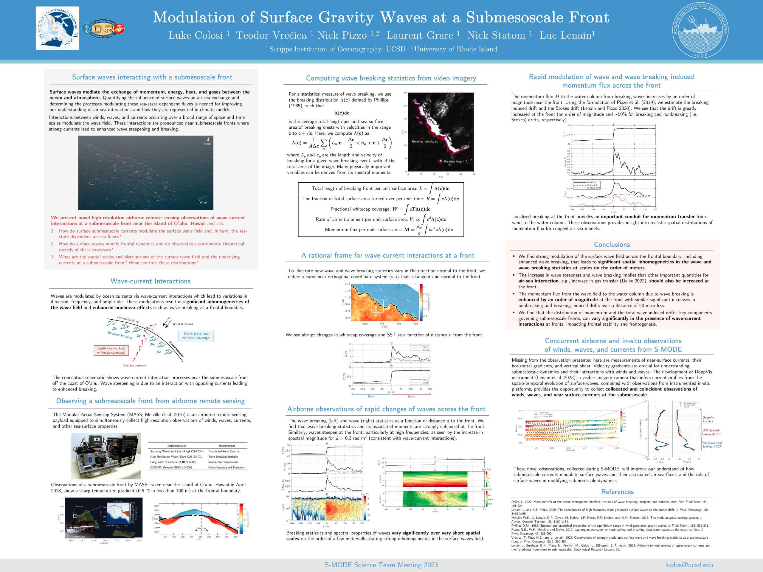 Surface waves mediate the exchange of momentum, energy, heat, and gases between the ocean and atmosphere. Quantifying the influence of surface waves on air-sea exchange and determining the processes modulating these sea-state dependent fluxes is needed for improving our understanding of air-sea interactions and how they are represented in climate models.
Interactions between winds, waves, and currents occurring over a broad range of space and time scales modulate the wave field, These interactions are pronounced near submesoscale fronts where strong currents lead to enhanced wave steepening and breaking.
Airborne Remote Sensing of Surface and Internal Wave Processes on the Inner Shelf
 The inner shelf, bounded on the shoreward side by the surf zone and offshore by a depth of approximately 50 100 m is a region in which a variety of physical processes can occur over a wide range of time scales (from fractions of a second for wave breaking, to the two week spring neap tidal cycle and seasonal cycles), and length scales (millimeters for the wind stress supporting gravity capillary waves and other microstructure, to O( 10 100 km) of along and across shelf processes) associated with a wide range of different forcings In this work, we report on a large field campaign conducted off the coast of Point Sal, CA in September 2017 as part of the Office of Naval Research funded Departmental Research Initiative ( Inner Shelf program We used a combination of airborne remote sensing techniques along with in situ surface and subsurface measurements to investigate the role of surface and internal wave processes on the dynamics, transport and mixing in the water column of the inner shelf.
Airborne Ocean Topography Measurements in Support of the SWOT Mission
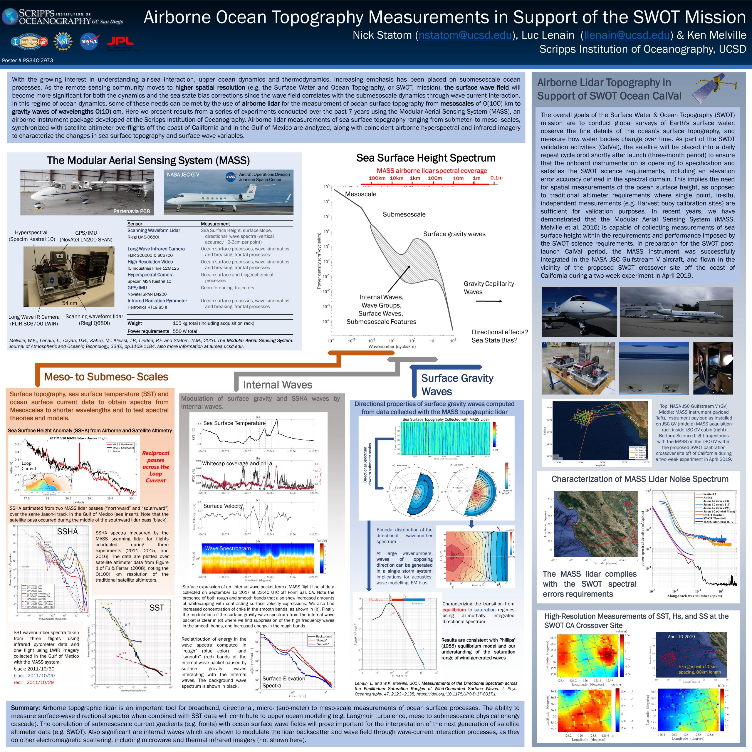 With the growing interest in understanding air-sea interaction, upper ocean dynamics and thermodynamics, increasing emphasis has been placed on submesoscale ocean processes. As the remote sensing community moves to higher spatial resolution (e.g. the Surface Water and Ocean Topography, or SWOT, mission), the surface wave field will become more significant for both the dynamics and the sea-state bias corrections since the wave field correlates with the submesoscale dynamics through wave-current interaction. In this regime of ocean dynamics, some of these needs can be met by the use of airborne lidar for the measurement of ocean surface topography from mesoscales of O(100) km to gravity waves of wavelengths O(10) cm. Here we present results from a series of experiments conducted over the past 7 years using the Modular Aerial Sensing System (MASS), an airborne instrument package developed at the Scripps Institution of Oceanography. Airborne lidar measurements of sea surface topography ranging from submeter- to meso- scales, synchronized with satellite altimeter overflights off the coast of California and in the Gulf of Mexico are analyzed, along with coincident airborne hyperspectral and infrared imagery to characterize the changes in sea surface topography and surface wave variables.
Shallow Water Bathymetric and Habitat Mapping of Coastal DoD Sites using Airborne Hyperspectral and Lidar Imagery
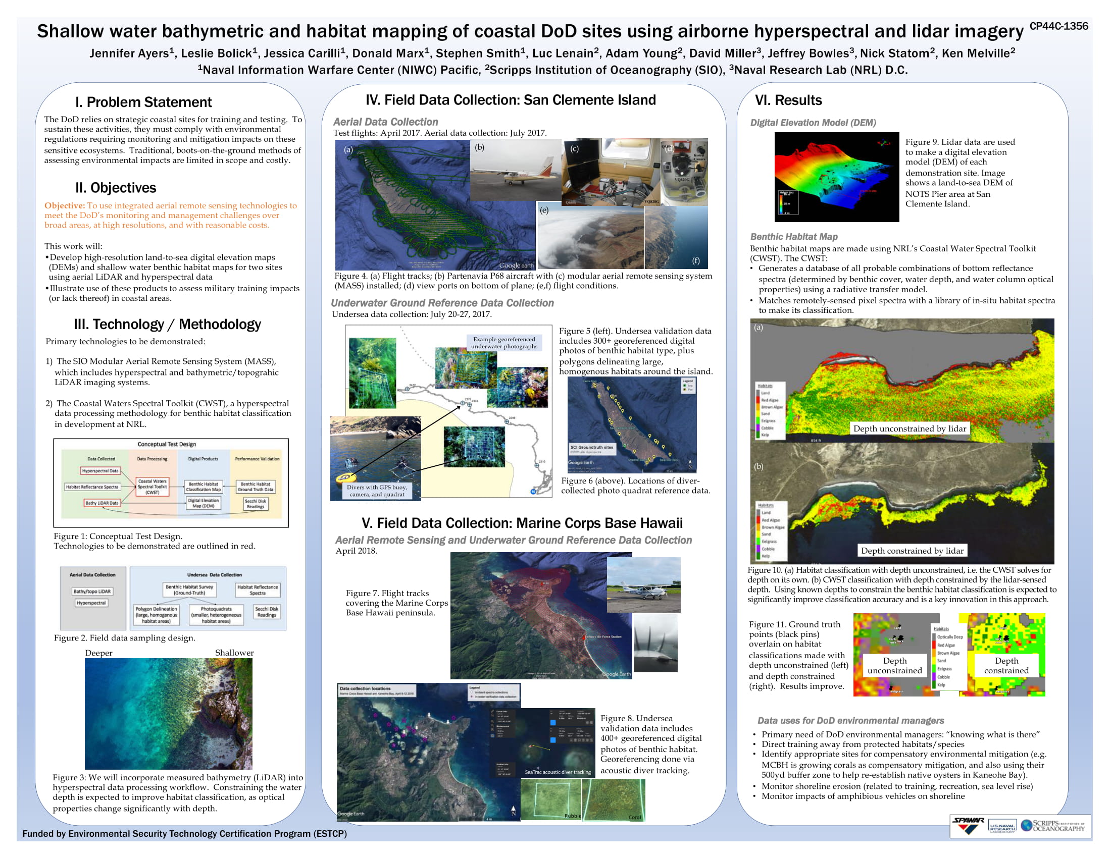 The DoD relies on strategic coastal sites for training and testing. To sustain these activities, they must comply with environmental regulations requiring monitoring and mitigation impacts on these sensitive ecosystems. Traditional, boots-on-the-ground methods of assessing environmental impacts are limited in scope and costly.
The objective for this experiment was to use integrated aerial remote sensing technologies to meet the DoD’s monitoring and management challenges over broad areas, at high resolutions, and with reasonable costs. This work will develop high-resolution land-to-sea digital elevation maps (DEMs) and shallow water benthic habitat maps for two sites using aerial LiDAR and hyperspectral data, illustrating the use of these products to assess military training impacts (or lack thereof) in coastal areas.
Lagrangian Transport by Breaking Surface Waves (2020)
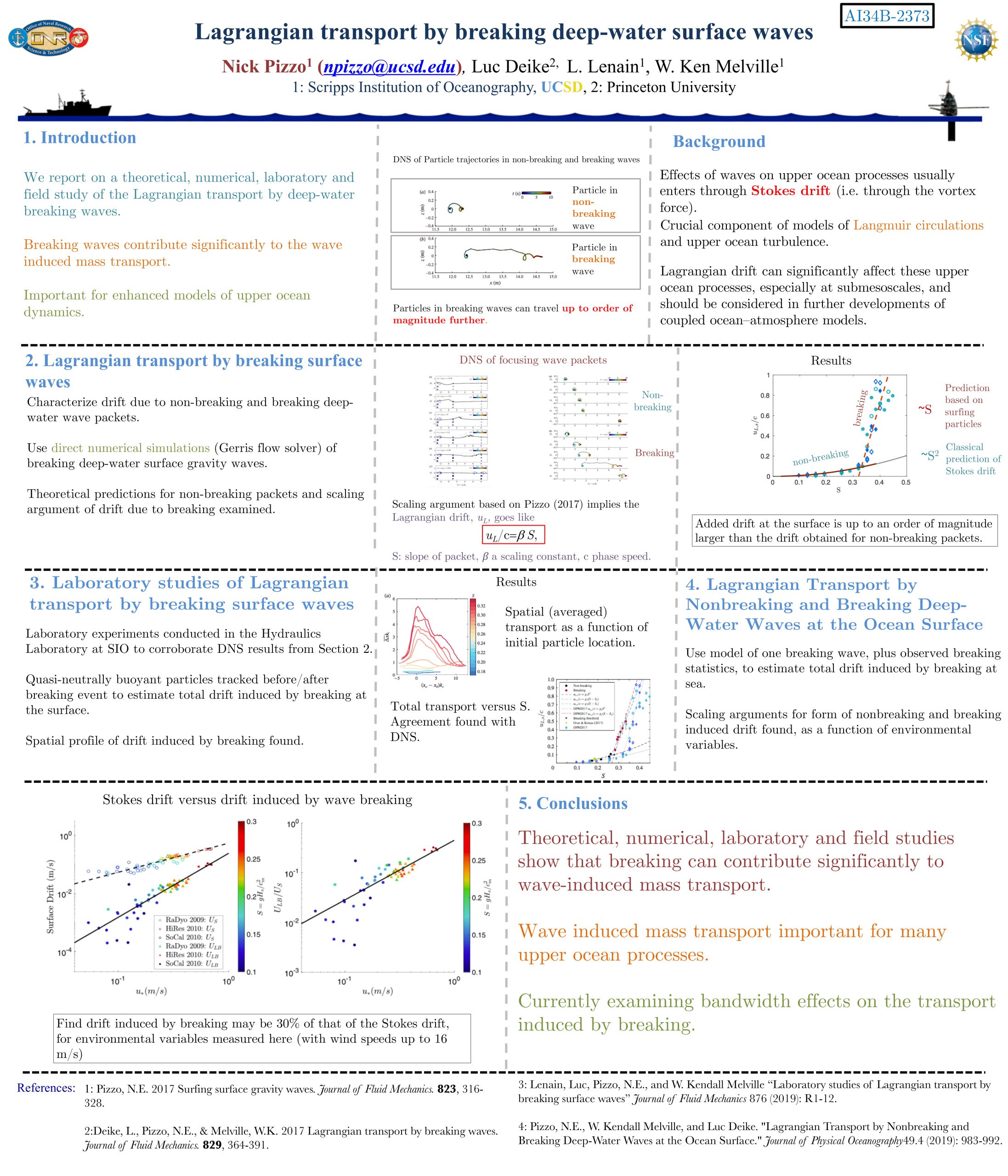 Effects of waves on upper ocean processes usually enters through Stokes drift (i.e. through the vortex force). Added drift at the surface is up to an order of magnitude larger than the drift obtained for non-breaking packets. Crucial component of models of Langmuir circulations and upper ocean turbulence. Lagrangian drift can significantly affect these upper ocean processes, especially at submesoscales, and should be considered in further developments of coupled ocean–atmosphere models. Here we report on a theoretical, numerical, laboratory and field study of the Lagrangian transport by deep-water breaking waves.
A Novel Multi-Sensor Airborne Mapping Tool for Ecosystem Monitoring
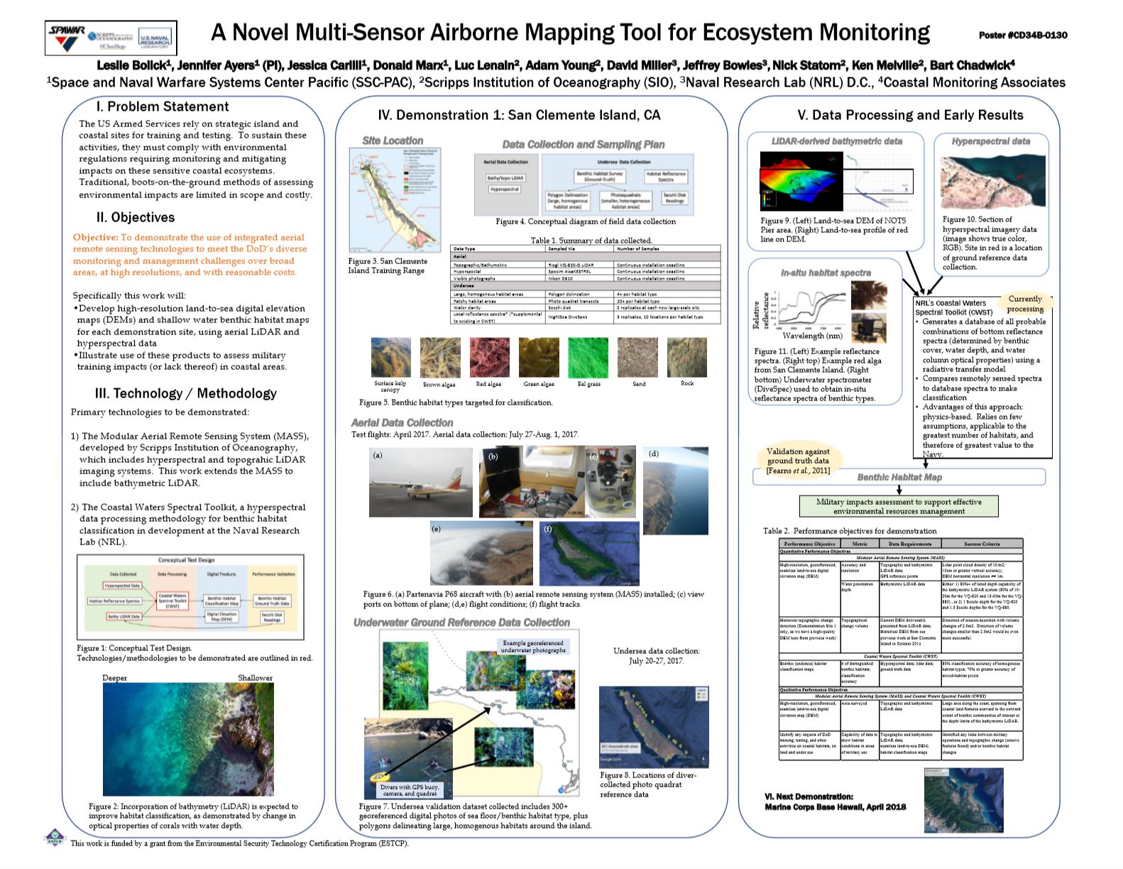 The US Armed Services rely on strategic island and coastal sites for training and testing. To sustain these activities, they must comply with environmental regulations requiring monitoring and mitigating impacts on these sensitive coastal ecosystems. Traditional, boots-on-the-ground methods of assessing environmental impacts are limited in scope and costly.
Our objective here is to demonstrate the use of integrated aerial remote sensing technologies to meet the DoD’s diverse monitoring and management challenges over broad areas, at high resolutions, and with reasonable costs.
Lagrangian Transport by Breaking Surface Waves (2018)
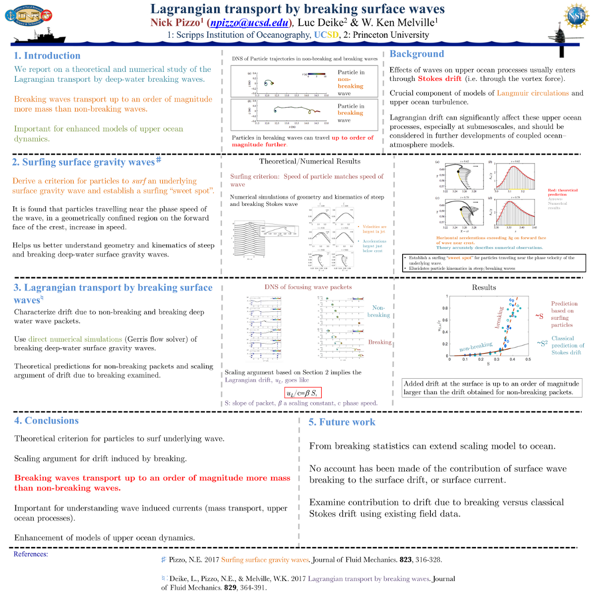 The effects of waves on upper ocean processes usually enter through Stokes drift (i.e. through the vortex force). This is a crucial component of models of Langmuir circulations and upper ocean turbulence. Lagrangian drift can significantly affect these upper ocean processes, especially at submesoscales, and should be considered in further developments of coupled ocean—atmosphere models. Here we report on a theoretical and numerical study of the Lagrangian transport by deep-water breaking waves.
Airborne Ocean Topography in Support of SWOT
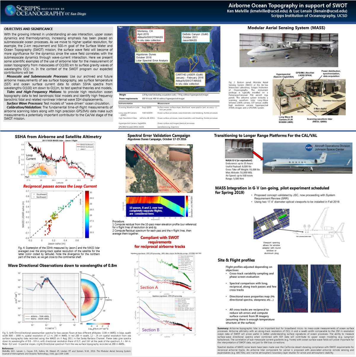 With the growing interest in understanding air-sea interaction, upper ocean dynamics and thermodynamics, increasing emphasis has been placed on submesoscale ocean processes. As we move to higher spatial resolution, for example, the 2-km requirement and 500-m goal of the Surface Water and Ocean Topography (SWOT) mission, the surface wave field will become of more significance for the dynamics since the wave field correlates with the submesoscale dynamics through wave-current interaction. Here we present some scientific examples of the use of airborne lidar for the measurement of ocean topography from mesoscales of O(100) km to surface gravity waves of wavelengths O(1) m.
Quantitative Comparison of Airborne Remote-Sensed and in situ Rhodamine WT Dye During RIVET & IB09
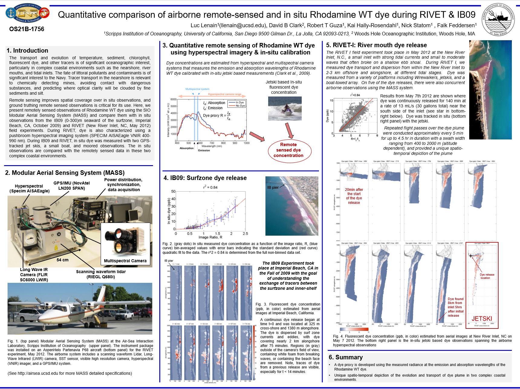 The transport and evolution of temperature, sediment, chlorophyll, fluorescent dye, and other tracers is of significant oceanographic interest, particularly in complex coastal environments such as the nearshore, river mouths, and tidal inlets. The fate of littoral pollutants and contaminants is of significant interest to the Navy. Tracer transport in the nearshore is relevant to chemically detecting mines, avoiding contact with dangerous substances, and predicting where optical clarity will be clouded by fine sediments and silt.
Remote sensing improves spatial coverage over in situ observations, and ground truthing remote sensed observations is critical for its use. Here, we present remotely sensed observations of Rhodamine WT dye using the SIO Modular Aerial Sensing System (MASS) and compare them with in situ observations from the IB09 (0-300)m seaward of the surfzone, Imperial Beach, CA, October 2009) and RIVET (New River Inlet, NC, May 2012) field experiments. During RIVET, dye is also characterized using a pushbroom hyperspectral imaging system (SPECIM AISA Eagle VNIR 400-990 nm). During IB09 and RIVET, in situ dye was measured with two GPStracked jet skis, a small boat, and moored observations. The in situ observations are compared with the remotely sensed data in these two complex coastal environments.
Airborne Lidar in Support of Ocean Topography Missions and Science
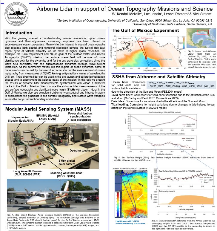 With the growing interest in understanding air-sea interaction, upper ocean dynamics and thermodynamics, increasing emphasis has been placed on submesoscale ocean processes. Meanwhile the interest in coastal oceanography also requires both spatial and temporal resolution beyond the typical (ten-day) repeat cycle of satellite altimetry. As we move to higher spatial resolution, for example, the 2-km requirement and 500-m goal of the Surface Water and Ocean Topography (SWOT) mission, the surface wave field will become of more significance both for the dynamics and for the sea-state bias corrections since the wave field correlates with the submesoscale dynamics through wave-current interaction.
As the community moves into this regime of ocean dynamics, some of these needs can be met by the use of airborne lidar for the measurement of ocean topography from mesoscales of O(100) km to gravity-capillary waves of wavelengths O(1) cm. Thus airborne lidar can be used in the pre-launch and calibration/validation phases and to supplement the science goals of the mission. In this talk we present the results of airborne lidar measurements synchronized with Jason 1 altimeter tracks in the Gulf of Mexico. We compare the airborne lidar measurements of the sea-surface topography and significant wave height (SWH) with Jason 1 data. In the Gulf of Mexico we also use coincident airborne hyperspectral and infrared imagery to characterize the gradients in sea surface topography and surface wave variables across the Loop Current boundary and eddies.
Development and Testing of Instrumentation for Ship-Based UAV Measurements of Ocean Surface Processes and the Marine Atmospheric Boundary Layer
 We have developed instrumentation packages for Unmanned Aerial Vehicles (UAVs) to directly measure air-sea momentum transfer, latent, sensible, and radiative heat fluxes, and surface topography.
The low altitude required for accurate air-sea flux measurements is below the typical safety limit of manned research aircraft; however, with advances in laser altimeters, small aircraft flight control, and real-time differential GPS (DGPS), it is within the capability of the UAV. Ship-launched UAVs can greatly increase the range of atmospheric and oceanographic measurements well beyond the immediate vicinity of the vessel, and enable investigation of spatial variability
Accurate air-sea measurements will lead to more robust models to relate near-surface atmospheric profiles to surface fluxes. These relationships are essential for improving oceanatmosphere coupled models for scales ranging from local weather to extreme weather events to global climate.
High-Resolution Airborne Waveform Lidar for Oceanographic Research
 It is now accepted that to better understand the coupling between the atmosphere and the ocean, surface-wave processes must be taken into account. Traditional airborne Lidar systems and in situ instrumentation have limited directional and frequency responses and do not have the resolution required to fully test modern theories of directional wave spectra. Directional observations at lower and higher wavenumbers, the latter being close to the end of the gravity-wave range, are especially limited, but are important as they need to be resolved in current wind-wave models.
Over the course of two years, we have integrated a novel, portable, high-resolution airborne topographic lidar with video and hyperspectral imaging systems. The scanning waveform lidar is coupled to a highly accurate GPS/inertial measurement unit permitting airborne measurements of the sea surface elevation and whitecap coverage with swath widths of up to 800m under the aircraft track over water, and horizontal spatial resolution as low as 0.2m. We describe system performance, and present preliminary results from recent measurements, where we obtained wave directional spectra down to wavelengths of 0.8m.
Measurements of EM Bias: Wave Slope and Altitude Effects
 Measurements of em bias at Ku band (14 GHz) were made from a platform in Bass Strait during the austral winter of 1992. Two Ku-band Doppler scatterometers were installed on the Snapper platform at 15 and 25m above MSL in 57m of water 30 km off the coast of Victoria, Australia. Approximately two months of data were collected and included microwave backscatter, microwave Doppler velocity, along with supporting wind and wave measurements. The normalized em bias b = e/Hs, where e is the em bias and Hs is the significant wave height, is usually correlated with the wind speed and significant wave height; however, this leads to significant anomalies at at low wind speeds where b typically has a finite value at zero wind speed, presumably due to the effects of residual waves and swell generated at remote locations. These measurements were carried out to examine em bias in strong wind and wave conditions at a site exposed to the Southern Ocean, to investigate improved parameterizations of the bias, and to study the effect of small altitude differences on em bias measurement.
The Sound of the Surf
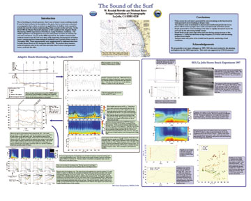 Waves breaking on a beach generate what is one of nature’s most soothing sounds. It may be better to leave its description to the poets, but in recent years acoustical oceanographers have taken an interest as applications in shallow water expand to include the need for a better understanding of the acoustics in the surf zone. In the fall of 1996 the Marine Physical Laboratory at SIO conducted the Adaptive Beach Monitoring (ABM) experiment at Red Beach, Camp Pendleton, California. The ABM experiment was designed to use active and passive acoustics to monitor the surf zone and beach. As part of the ABM experiment, the authors measured the ambient sound across the surf zone along with supporting measurements of surface waves, currents and local meteorological conditions over a period of three weeks in November 1996. These measurements were supplemented by additional data from La Jolla Shores Beach at SIO during the fall of 1997. We present these measurements of ambient noise in the surf zone and relate them to local wind-generated waves, swell and the tides.
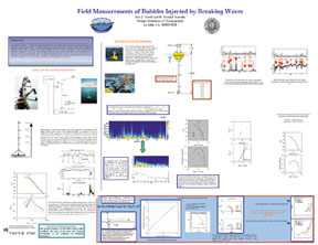
Bubble Entrainment by Breaking Waves and their Effects on the Inherent Optical Properties of the Upper Ocean
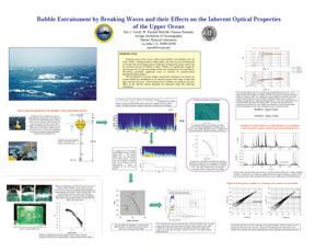 Breaking waves at the ocean’s surface inject bubbles and turbulence into the water column. During periods of rough weather, the scales of wave breaking tend to increase with increasing sea states, resulting in mixing of the surface waters and the turbulent transport of bubbles to depth. Bubbles can significantly change the optical properties of water depending on their concentrations and size distribution, introducing potentially significant errors in retrieval of remotely-sensed hyperspectral data products. The development of acoustic bubble measurement techniques now allows for oceanic bubble size distributions to be resolved across a wide range of radii with high temporal resolution. Field measurements of bubbles are presented and their effect on the inherent optical properties are estimated using Mie scattering calculations.
Laboratory Measurements of Langmiur Circulations and Turbulence
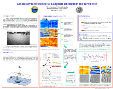 This poster describes the results of the laboratory experiments of the initial stages of the surface flow when a body of water is exposed to an increasing wind stress starting from rest. The laboratory measurements show that when exposed to an increasing wind starting from rest, surface current and wave generation is accompanied by a variety of phenomena that occur over comparable space and time scales. Of particular interest is the generation of small scale, streamwise vortices, or Langmuir circulations; the clear influence of the circulations on the structure of the growing wave field, and the subsequent transition to turbulence of the surface flow. Following recent work by Melville, Shear & Veron (1998) and Veron & Melville (1999), we show that the waves that are initially generated by the wind are then strongly modulated by the Langmuir circulations that follow. Direct measurements of the modulated wave variables are qualitatively consistent with geometrical optics and wave action conservation, but quantitative comparison remains elusive. The onset of the Langmuir circulations leads to a significant increase in the heat transfer across the surface. The implications of the measurements for air-sea fluxes, especially heat and gas transfer, and sea-surface temperature, are discussed.
Laboratory and Field Measurements of Turbulence under Breaking Waves
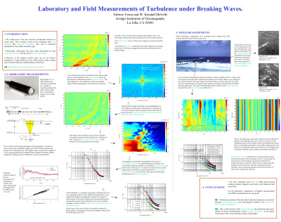 This poster presents laboratory and field testing of a pulse-to-pulse coherent acoustic Doppler profiler for the measurement of turbulence in the ocean. In the laboratory, velocities and wavenumber spectra collected from Doppler and Digital Particle Image Velocimeter (DPIV) measurements compare very well. Turbulent velocities are obtained by identifying and filtering out deep water gravity waves in Fourier space and inverting the result. Spectra of the velocity profiles then reveal the presence of an inertial subrange in the turbulence generated by unsteady breaking waves. In the field, comparisons of the profiler velocity records with a single point current measurement are satisfactory. Again wavenumber spectra are directly measured and exhibit an approximate -5/3 slope. It is concluded that the instrument is capable of directly resolving the wavenumber spectral levels in the inertial subrange under breaking waves, and therefore is capable of measuring dissipation and other turbulence parameters in the upper mixed layer/surface-wave zone.