
Modular Aerial Sensing System (MASS)
The MASS is a portable package of high-resolution instrumentation built specifically for airborne remote sensing applications. Instrumentation includes an airborne topographic lidar integrated with video, infrared, and hyperspectral imaging systems. The system is coupled to a highly accurate GPS-aided inertial measurement unit (GPS IMU), permitting airborne measurements of sea surface displacement, temperature, and kinematics. These data are used to measure ocean waves, currents, Stokes drift, sea surface height (SSH), ocean transport and dispersion, and biological activity. Hydrological and terrestrial applications include measurements of snow cover, sand erosion, and the built environment. The MASS has around 1000 hours of accumulated flight time over the course of over 40 different field campaigns and has been installed on Gulfstream V, Twin Otter, Partenavia P-68, Cessna 206, Piper Navajo, and Piper Twin Comanche fixed wing aircrafts as well as on a Bell 206 helicopter. A lightweight version of the MASS has been developed for our UAV multirotor platform.
Primary MASS Instrumentation:
Riegl VQ-780 II-S scanning waveform lidar
FLIR SC6700SLS longwave infrared camera
Specim AisaKESTREL10 hyperspectral camera
IO Industries Flare 12M125-CL video camera (RGB or monochrome)
Nikon D850 digital SLR RGB camera
Phase One iXM-GS120 RGB camera
Heitronics KT19.85 II infrared thermometer
Novatel SPAN ISA-100C inertial measurement unit
Novatel PwrPak7 GPS receiver
Legacy MASS Instrumentation:
Riegl LMS-Q680i scanning waveform lidar
FLIR SC6000 longwave infrared camera
Specim AisaEAGLE hyperspectral camera
Jai Pulnix AB-800CL video camera
Nikon D810 digital SLR camera
Novatel SPAN LN200 inertial measurement unit
Novatel ProPak6 GPS receiver
MASS Media
Datasheet PDF for MASS system.
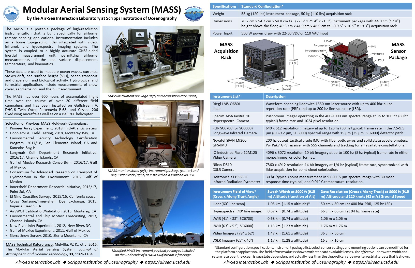
Image gallery of the MASS installed in various configurations. Click on images for a description.


Installation timelapse of an older iteration of the MASS at Aspen Helicopter in Oxnard, California on a Partenavia P68 in June 2015.
MASS Related Publications
A selection of Modular Aerial Sensing System (MASS) related publications.
General Description and Capabilities:
The Modular Aerial Sensing System (Melville et al., 2016)
Ocean Surface Topography and Kinematics:
A Broadband View of the Sea Surface Height Wavenumber Spectrum (Villas Bôas et al., 2022)
Lifecycle of a Submesoscale Front Birthed from a Nearshore Internal Bore (Haney et al., 2021)
Modulation of Surface Gravity Waves by Internal Waves (Lenain et al., 2021)
Airborne Measurements of Surface Wind and Slope Statistics over the Ocean (Lenain et al., 2019)
Untangling a Web of Interactions Where Surf Meets Coastal Ocean (Lerczak et al., 2019)
Surface Measurements: Observations of Surface Wave-Current Interaction (Romero et al., 2017)
Nearshore Dye Tracer Evolution:
Observations and Modeling of a Tidal Inlet Dye Tracer Plume (Feddersen et al., 2016)
Aerial Imaging of Fluorescent Dye in the Near Shore (Clark et al., 2014)
Land Topography:
Southern California Coastal Response to the 2015—2016 El Niño (Young et al., 2018)
San Clemente Island Baseline LiDAR Mapping Final Report (Chadwick et al., 2016)